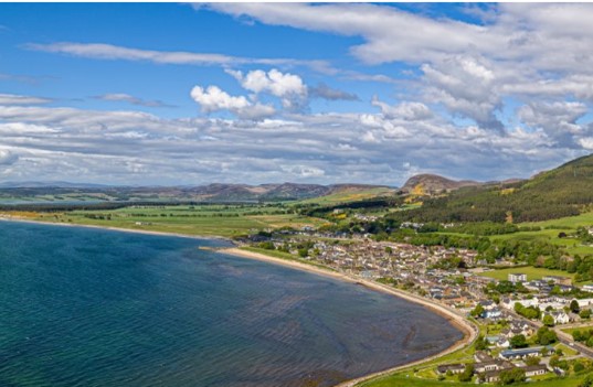
Golspie (population approximately 1350) is a beautiful coastal village and parish in Sutherland, Highlands which lies on the North Sea coast in the shadow of Ben Bhraggie. Golspie is the ‘gateway to the north’; it is the first built up area motorists are forced to drive through on a major trunk road after leaving the continent (all other conurbations are bypassed) as the A9 runs straight through Main Street following the coastline up into North Scotland. It lies on the North Coast 500 (NC500) which has been described as one of the world’s most beautiful road trips. The main ‘Far North Railway line’ operated by Scotrail also runs through the village. The picturesque village has many tourist attractions including Dunrobin Castle and Gardens, an award-winning beach, Loch Fleet national nature reserve, the Duke of Sutherland Monument, the Highland Wildcat Mountain bike trails, Littleferry battlefield trail, North of Scotland Kart Club, Singing Sands caravan park as well as a multitude of sports and outdoor recreation activities including the 1889 golf course which was influenced in design by the great James Braid.
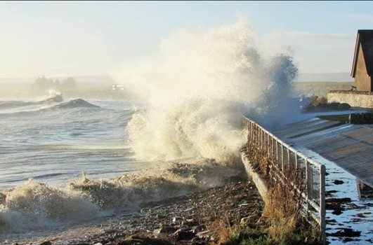
However, Golspie has been designated a POTENTIALLY VULNERABLE AREA (PVA) by the Scottish Environment Protection Agency (SEPA) since 2011 and has suffered significant coastal erosion and flooding over the years. It has also been named as one of Scotland’s 10 Most Endangered Areas. As the main arterial A9 road and the Wick to Inverness Scotrail railway runs directly through the village and if these were to become damaged and impassable, then all villages and towns north of Golspie would be in effect ‘cut off’ from the rest of the United Kingdom. This impact far outweighs the small size of Golspie itself. A nursing home, one designated cultural heritage site and areas of environmental importance are also at risk. These include the Dornoch Firth and Loch Fleet Special Protection Area and Loch Fleet Site of Special Scientific Interest.
Since 2005 there have been seven river and surface water floods that have affected roads and property and 3 of these have occurred in late 2023 and early 2024. Damage to the coastline is significant with properties suffering from flooding, the promenade becoming unsafe to use, damage to the sea wall, the Pier and harbour area with the beach access being washed away in places. In addition, surface water and river flooding was also experienced by properties situated around Argo Terrace as water from the hill flooded over the railway line onto the road due to the old Victorian drainage system (which is in desperate need of repair) being overwhelmed. This flooding also caused the A9 to be closed for a number of hours in late December 2024 thus cutting off the main arterial route to the north of Scotland.
The risk of flooding to people and property, as well as to community facilities, utilities, the transport network, designated sites and agricultural land is now happening and it is imperative that action is taken NOW. The coastline and village has been the subject of various surveys and reports (6 in the last 20 years.) but to date no significant action has been taken to manage this real problem.
British camping brand Vango has commissioned a study in cooperation with the University of Glasgow that names 10 well-loved Scottish camping areas that could be at risk due to climate change. The University of Glasgow undertook a Scotland-wide analysis of coastal erosion risk (www.dynamiccoast.com), including identifying more than ten coastal sites that will soon shrink dramatically through the impacts of sea level rise, strong wave action, and coastal flooding. You can view the map below which shows Golspie is one of those 10.