The Plan
A short term plan (to cover the next 10 years or so) is currently being drawn up to try to slow down the effects of the coastal errosion and village flooding that is currently happening at an alarming rate. Below is an outline of what is currently on the table. A long term plan (to cover the next 50 to 100 years or so) will take much more consideration, planning and funding and an outline of this can be found under the THE FUTURE PLAN web page.
Protect the Village, Protect the A9, Protect the Future
The village has been divided into 5 ‘zones’ which are based on those agreed with the Community Council and Go Golspie. These zones consist of:
- Zone 1 – Broch to Big Burn (Dunrobin Castle to where the Golspie burn meets the coast (Off Duke Street))
- Zone 2 – Benn Bhraggie, Dunrobin Glen & Backies
- Zone 3 – The Village
- Zone 4 – Harbour to the Helipad.
- Zone 5 – Golf course to Littleferry, including fields between A9 and Littleferry
See the plan for each zone below:

ZONE 1 PLAN – Broch to Big Burn
Currently, the seawall and revetments in place which are nearly 150 years old are providing good protection to the castle and grounds. However, the footpath that runs from the Golspie burn to the castle along the coast and ‘Dairy Park’ is being washed away regularly at every high tide. This is bringing in lots of stones etc and is forming a natural ‘bank and berm’ (See FAQs) which is protecting the area to an extent. Therefore, it has been decided to let ‘Mother Nature’ take her course.
October 2025 Update –
- This area mostly requires monitoring of coastal changes, but the shoreline footpath may require re-routing if erosion at the fossil beds continues. CoastSnap citizen science technology may be an option for this.
- Collaboration between Sutherland Estates, Network Rail, Highland Council and BEAR Scotland is needed to resolve the flooding problem at the Dunrobin Sawmill junction with the A9. Highland Council did not attend the site meeting with Network Rail back in February, so there has been no further work on this.
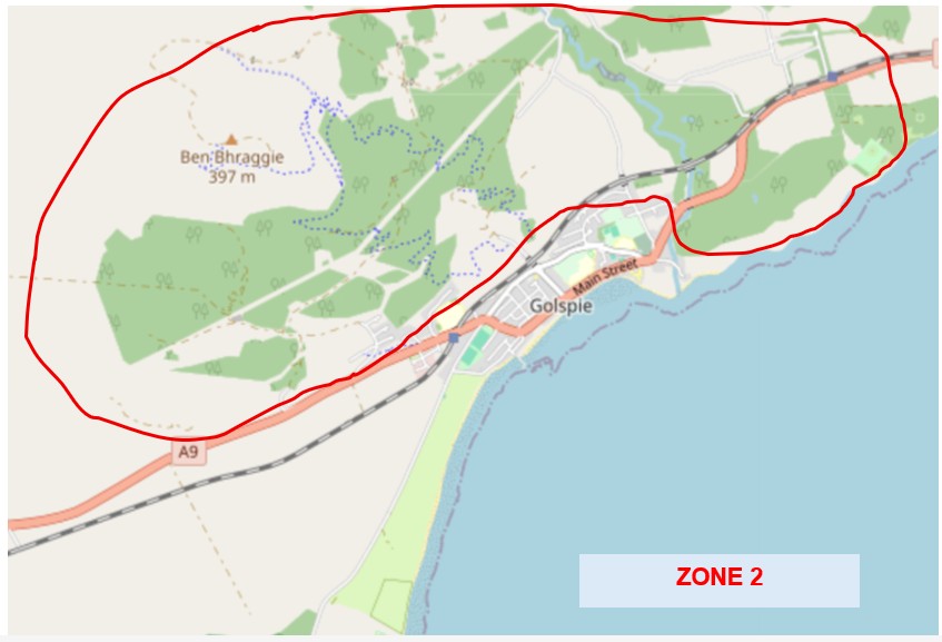
ZONE 2 PLAN – Benn Bhraggie, Dunrobin Glen & Backies
- Sutherland Estates will start Phase 2 of its peatland restoration project this winter and continue next winter. The area to be restored is on the north side of Dunrobin Glen road from Loch Horn towards the coast.
- Discussions between SSEN and the flood group sub committee of the community council are at an early stage, to scope the pylon line (if it goes ahead) contractors’ support to put in ‘leaky dams’ at flood risk locations on the hill. Initial indications are positive.
Both these initiatives will help to slow water runoff from the hill into the village during periods of heavy rainfall. For reference, Golspie’s flood risk is 17% from rivers, 20% surface water, 64% coastal.
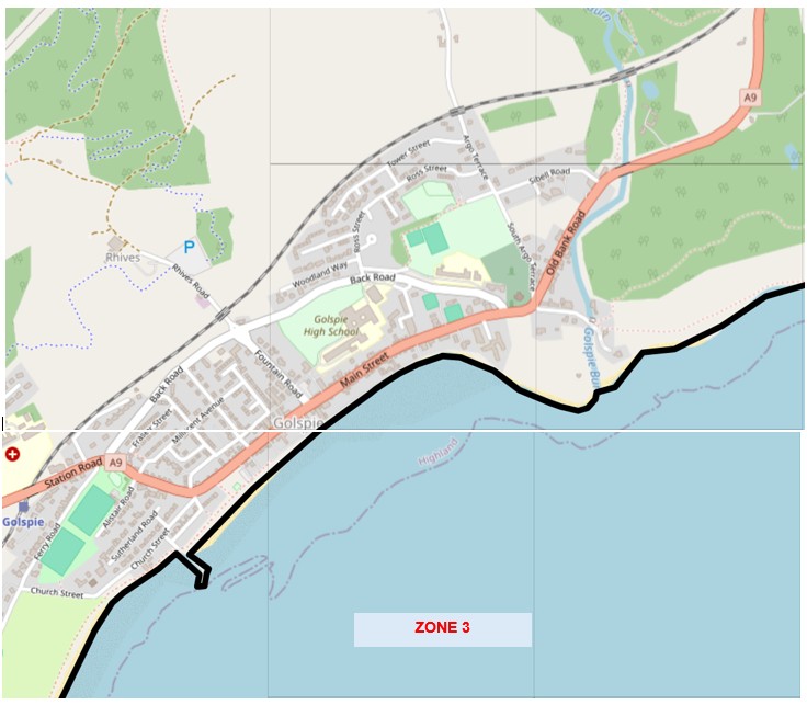
ZONE 3 PLAN – Golspie Village
Currently, the village and surrounding area including the A9 heading North from Golspie suffers from excessive flooding during storm and heavy rain weather. This is due to surface water overwhelming the very old drainage system that was designed during the Victorian era when there were few houses residing on the slopes of Ben Bhraggie. Argo Terrace was particularly badly affected at the end of 2023 during storm Babet with some houses being flooded out. In addition, the A9 was impassable due to flooding for a number of hours around Nursery Road which leads to Backies. Since then, Golspie Flood Action Group has been active, engaging with the Scottish Flood Forum who visited the village to give advice on how to protect properties as well as carrying out free surveys on individual properties. Please see NEWS AND EVENTS for more information.
October 2025 Update
- Over 50 water butts have been supplied in the village, with only a couple still to be fitted. We are grateful to Go Golspie for making available some of the Renantis (Kilbraur) funding for this initiative. Installing a water butt can help and if everyone did this in the village, this would help the existing drainage system to cope! Please see WHAT CAN I DO? for more information.
- Negotiations with Tulloch Homes for repair of the land drains to the south of the railway line above Sibell Road are underway. This area is zoned for housing and has never been developed since the land was purchased by Tulloch Homes. This overlaps with the place plan and the need for local affordable housing.
- Network Rail have been put in touch with local farmer/landowners to scope the option of a combined drainage ditch/cycle & foot path along the north side of the railway through the village as detailed in the local place plan. This would ease flooding from the hill onto the railway line and into private gardens.
- Highland Council have recently cleared the street drains in the village, and we are pressing the Roads Department to commit to a regular programme of maintenance and repair of these drains. This would considerably help storm drains from being overwhelmed.
- The 2 council owned water outfalls (Chemist Lane & helipad) damaged during Storm Babet in October 2023 still have not been repaired. The chemist lane outfall work was put out to tender, but no contractor came forward.
- A small amount of funding has been identified from the Active Travel council budget to re-surface the promenade, but it will be to a lower standard than below the chemist lane, as the upper section is not an adopted road (although still owned by Highland Council).
- Highland Council Flood Risk Management Team is being very supportive in progressing the project to install a groyne alongside the failing pier along side CoastSnap citizen science technology to monitor coastal changes. Environmental consultants Affric Ltd have been engaged to support the application for marine licensing. The cost for the whole project is estimated at £800k, of which £350k is already secured (£105k Coastal Communities Adaptation Fund, £250k Gordonbush windfarm extension community benefit funds agreed in an MOU in 2021). So a further £550k will be required, although we are hoping to reduce substantially the overall cost by use of local supplies and contractors.
- Highland Council preferred flood scheme of raising seawall by 90cm is still in the pool for £1.5M Scottish Government, Cycle 2 capital grant funding. However, the total spend on cycle 1 schemes is still not final, so the amount that can be spent in cycle 2 is not known. A decision was expected in spring this year, but has now been delayed until spring 2026, when the Scottish elections will take place. The bank & berm proposal commissioned by Go Golspie will achieve the same effect of raising the seawall but in a more aethetically pleasing construction and estimated to cost £5M with little or no ongoing maintenance. The most environmentally acceptable option recommended by Affric Ltd is a series of groynes with beach re-charge, estimated to cost £7M & would require periodic import of sand. This latter might be available from Ardesier port once the requisite licences and permissions are obtained.
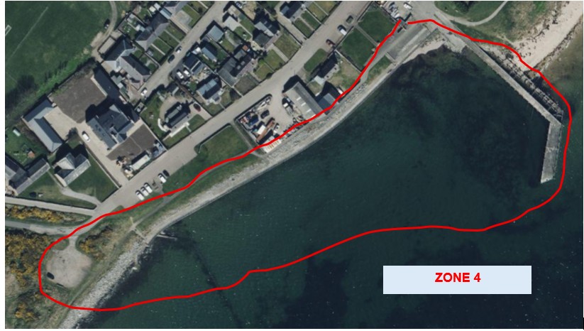
ZONE 4 PLAN – Harbour to Helipad
- Seafront walkway repair after Storm Babet is still outstanding. This is a Highland Council Roads Department responsibility. The promised design plans to make this safe and secure again, including the water outfall at the helipad, have still not materialised. The council has been made fully aware that the HERAS fencing, which has been there for 18 months, now poses more of a risk than the damaged walkway as it keeps getting blown down by the wind.
- A suggestion has been put forward that the helipad area could be developed into an amenity area similar to the bottom of the Shore St carpark, with benches & perhaps a pop up coffee/ice cream stall or similar. Public views on this?
- The new beach access has been very popular and hugely well received by residents and visitors alike. Huge thanks to all those responsible!
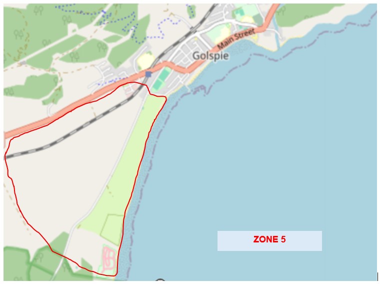
ZONE 5 PLAN – Golf course to Littleferry, including fields between A9 and Littleferry
Sutherland Estates owns the coastline which runs from the helipad down along the Golf Course, Caravan Park, Go Kart Track and all the way to Littleferry. However, Golspie Golf Course are responsible for the coastline from the 5th Green to the area by the 7th Tee. They carried out work to remedy the destruction of some of this area after the devastating storms that occured in 2012 and 2014 bolstering it by putting in gabions and rock armour. They also completed works to the 7th Tee after the storms and high tides of late 2023 and early 2024 damaged this area again, spending approximately £80K putting in more gabions and rock armour. After the storms of 2012 and 2014 the Highland Council, who had access at that time to manpower, money and materials, carried out works to replace the existing rock armour along the section from the helipad to the 5th fairway. Extensive damage occured again after the latest storms with many metres of fairway being lost. The coastal pathway that runs from Littleferry up to Golspie does not exist in places anymore.
The shoreline along the Go Kart Track has had considerable investment over the years by the club with the installation of rock armour and this is still ongoing. Golspie Flood Action Group are keen to work with the club and share any ideas, trials that may be suitable for this coastline.
The shoreline by the Caravan Park has been repaired by the new owners in recent months.
October 2025 Update
- Support to the golf club, kart track and caravan park if and when requested. Contacts for concrete mattresses and rock filter units to use in defending against more coastal erosion have been passed on and introductions made.
- Work with NatureScot with advice from Dynamic Coast to monitor coastline changes along Littleferry Dunes and within Loch Fleet. CoastSnap citizen science technology might be an option here too.
- Network Rail contractors have already completely repaired the drainage channel through fields below Kirkton Farm. It is now up to Network Rail to ensure proper maintenance.
- Still no information on the identity of the purchaser of the field next to the Business Park which also requires major repair to the land drainage network there.
© Golspie Flood Action Group 2025